Understanding How Equity Communities Travel
Using LOCUS Transit Insights to study equity community travel patterns and transit needs.
Hurricane Helene, the Category 4 hurricane that brought torrential downpour and catastrophic flooding to North Carolina, claimed over 200 lives and left millions without power in its aftermath. Post-hurricane assessments indicate that over 24 inches of rainfall inundated parts of the Asheville region over the course of three days. Nearly two months later, road closures and other impacted services continue to severely affect the movement of people, goods, and services.
North Carolina’s preliminary damage and needs assessment reports an overall cost of over $53 billion, of which an estimated $9.8 billion was assigned to damages to the transportation system. Nearly 6,000 miles of roads and over 1,000 bridges and culverts were disrupted and damaged by the hurricane. The NCDOT Road Reopening dashboard for Helene reports over 1,300 road closures affiliated to the hurricane. According to the NC Department of Transportation, I-40 and I-26 remain closed with unclear reopening times.
Disruptions ushered by mega-weather disasters often have overwhelming impacts on both personal travel and the movement of goods. However, the impacts of Helene are particularly noteworthy in regions that were previously considered relatively safe from hurricane impacts. Emergency and resilience preparedness are no longer the domain of cities and towns in the direct line of sight for extreme weather conditions.
The question facing us now is this: how can we prepare towns and regions that have been previously unexposed to extreme weather events, especially hurricanes, and what can we learn from the devastation of Hurricane Helene in Western North Carolina?
Much has been written about the unique mix of topography, preceding weather events, and recent development in the region that may have contributed to the devastating impact of Hurricane Helene in the region. These include:
We have documented local and inter-regional disruptions from the hurricane through our LOCUS platform.
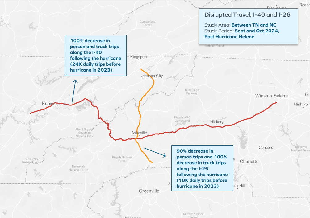
The interstate is the lifeblood of commerce and for personal travel, especially commute travel. In the week before the hurricane hit, most trips between Eastern Tennessee and Western North Carolina took place on I-40 (24k daily trips in 2023) and I-26 (10k daily trips in 2023).
In the week following the hurricane, no passenger vehicle or truck trips were observed using I-40 owing to closures. Similarly, data on the LOCUS platform showed that I-26 had no truck trips, while passenger vehicle trips dropped by 90%.

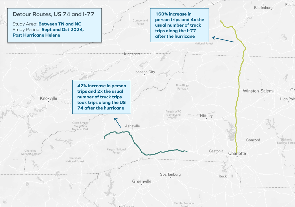
Official detours for personal vehicles traveling to Tennessee along the impacted route include US 74 and I-77. US 74 saw a 42% increase and I-77 saw an over 160% increase in passenger vehicle trips from North Carolina to Tennessee after the hurricane. Similarly, nearly four times the typical number of truck trips were observed on I-77 and twice the number of truck trips were observed on US 74 after the hurricane. In places with no such alternative routes, the negative impact of a major weather event can be even more devastating.

Having reviewed similar data across the country, we have observed that regions with significant number of culverts and bridges have experienced greater traffic disruptions (and for a longer duration) in the event of a major rain/wind weather event.
Due to the added travel times associated with the detours, it is possible that many trips were simply cancelled altogether. For instance, total passenger vehicle trip-making between Tennessee and North Carolina (across all routes) dropped by about 80% and total truck trip-making dropped by about 50%.
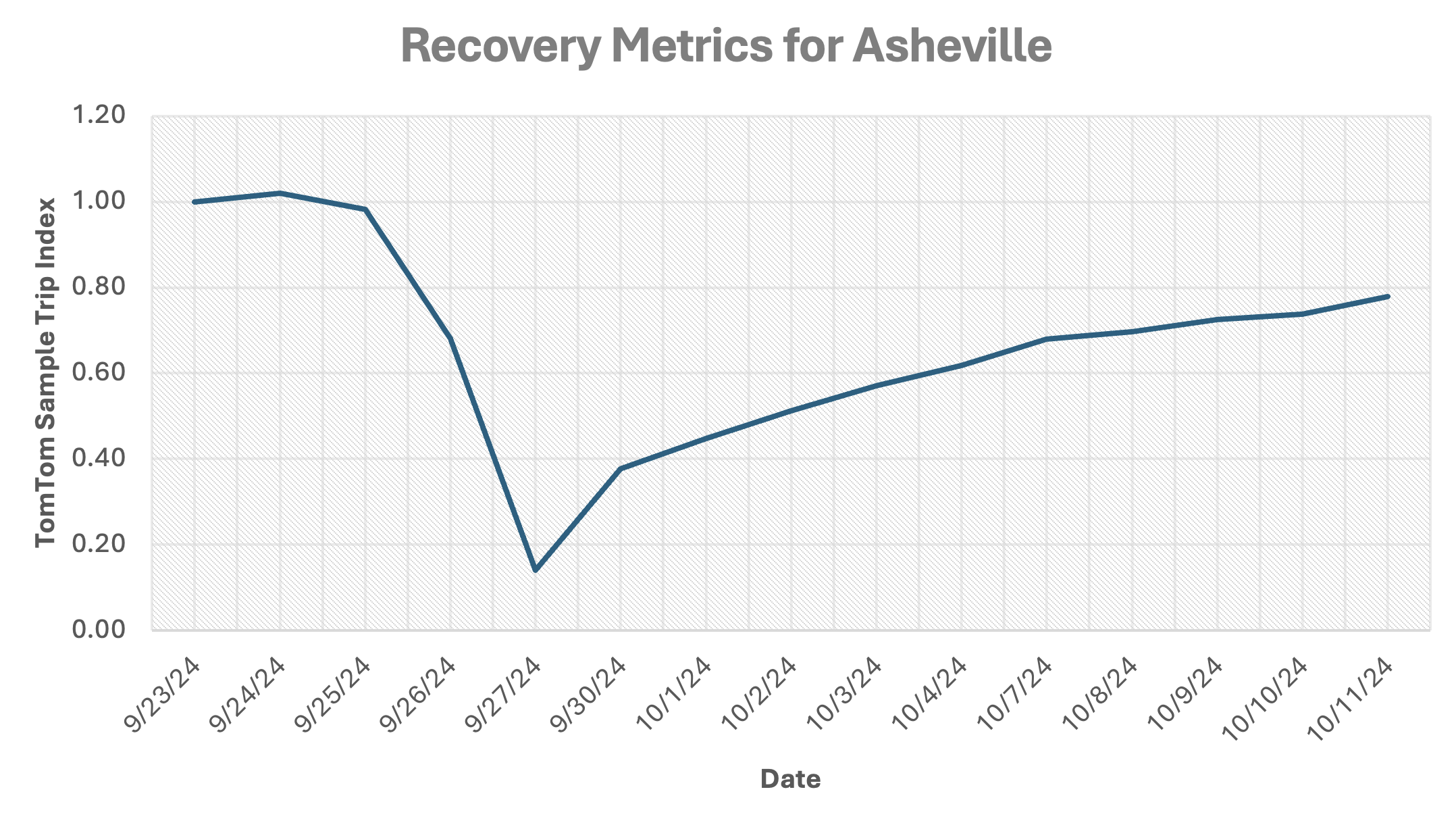
As a result of restrictions on heavy-duty commercial vehicles (greater than 30 feet long), Bloomberg is reporting a loss of over a billion dollars in trade and commerce. Our sample data in LOCUS also shows that trip recovery was still at 80% for the Asheville community three weeks after the hurricane.

In addition to the stress placed on communities and freight services by such disasters, weather events often cause disproportionate harm for low-income and minority travelers. People belonging to these groups may not have the resources to make alternate travel arrangements or even to evacuate, often from high-risk areas. This results in damage to life, property, and the economic system at large.
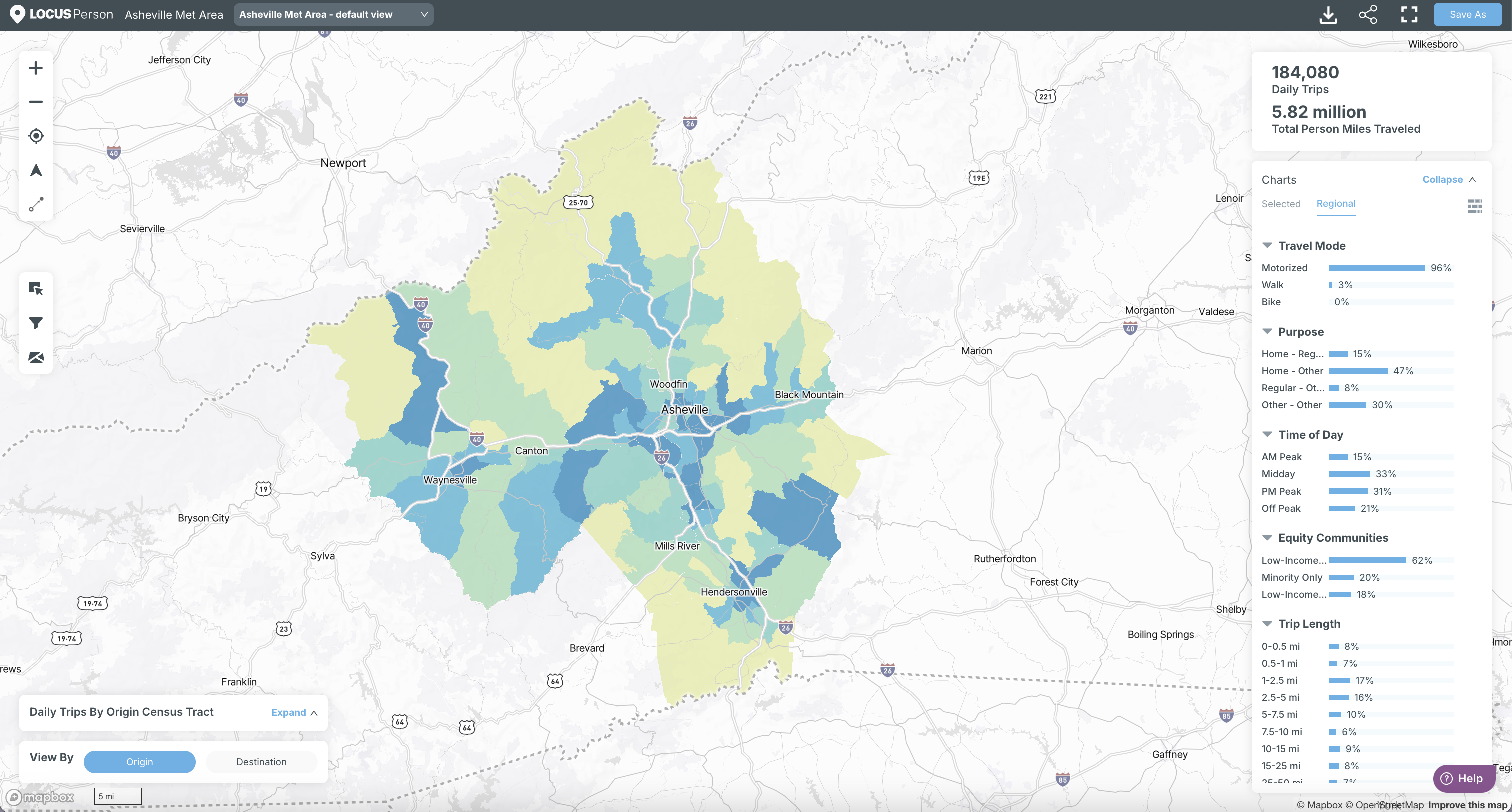
According to the USDOT Equitable Transportation Community (ETC) explorer, over 30,000 people live in disadvantaged communities. LOCUS data indicates that 184,000 daily trips were made by these disadvantaged community residents, and the active transportation mode share for these communities was 3%.

Weather events could have medium and perhaps longer-term implications for the supply chains of specific goods. One such example is the town of Spruce Pine, which plays a pivotal role in the global network of semiconductors. The production of microchips and solar panels are supported by quartz mines in this area, and the flooding puts the availability of this material at risk.
LOCUS can be used to analyze truck trips from this community (and others) over time and assess the impacts on commercial vehicle movements.
As insurance costs surge, many homeowners and business owners – especially those from low-income groups and small businesses – may choose to relocate to areas that have more predictable weather and, hence, insurance costs. This can have a crippling effect on regional and statewide economies.
For instance, using a NCDOT Benefit-Cost Analysis Memorandum, the number of trips that would have been made but were not (known as “foregone trips”) can be valued. Foregone work trips are reported as having a cost of $53.90. Based on our experience, we assume that a quarter of foregone trips in Asheville are work trips, and that non-work trips can be valued at roughly half of work trips. Further, we know that the sample data above represents roughly a quarter of the actual number of trips on the ground.
We can estimate the cost of the foregone trips in Asheville between September 26th and October 11th (12 weekdays) as outlined in the chart above at over $77 million.
To better understand and mitigate the potential impacts of natural disasters on regions and communities, data such as LOCUS can be used in three critical ways:
Using LOCUS Transit Insights to study equity community travel patterns and transit needs.
Learn how the new company will be providing innovative transportation solutions through advanced analytics and data integration.
LOCUS partners with CALSTART to support freight electrification along the I-95 corridor
Be the first to know whenever there's a new post on our blog, where we share insights into all things big data and travel behavior.